Lab1 (GIB1_HT12)
In this exercise we will georeference a raster image and make a data capture by manual vectorisation of the roads and pathways visible in the image. Different levels of geometric generalisation of the roads and pathways will be studied and compared to available data showing buildings in the same area. The programs that will be used are IDRISI Taiga, MapInfo 10 and ArcMap 10.
Georeferencing and vectorisation
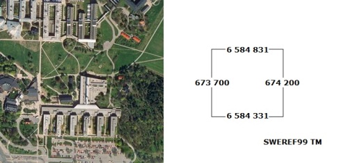
The photography 10I6F9G.TIF (see below) shows a part of the Stockholm University area.
The files used in all the labs are stored in the catalog GIB1_HT12 in T:\. Move the whole catalog to: D:\Und…\ before starting.
The coordinates used in this laboration is SWEREF99. But when we are using the coordinates in the programmes we tell the program we using the reference system/projection: non earth or plane (meters).
Start Idrisi, open the image and give it the correct coordinates (the coordinates are shown to the right of the image above). The procedure to import a TIFF file in Idrisi and give the image coordinates are described in the article: Georeferencing with IDRISI Taiga.
When the new image opens you might need to change the palette file. Use the one created when you imported the TIFF.
The next step is to export the image (raster file) from Idrisi and import it into MapInfo.
In MapInfo the roads and pathways visible in the photography should be drawn as vectors. Try to capture the details in the shapes.
The last step of this part Georeferencing and Vectorisation is to move the vector data from MapInfo to IDRISI.
Generalisation of vector data
The level of generalisation regarding the shapes (geometry) of geographical data is to a large extent dependent on the scale the data will be used for. Many and small details are nessecery in large scale maps but make small scale maps hard to read and use a lot of space when stored digitally.
The next step in this exercise is to take the vector file you have created and make a version with less details. Instructions for doing this is described in the article: Geometric generalisation with IDRISI Taiga (there is also a version in Swedish). Use Tolerance band and Tolerance value: 15.
The original version of the vectorised file and the generalised version of the vectorised file should now be exported as Shape files.
Open ArcMap 10 and add the two shape files, together with the three Shape files with buildings in the area: by1, by2 and by3.
To hand in after the lab
1. Compare the five files in different scales and try to conclude the scale each of them are suitable for, write down your conclusions on a paper.
2. Draw a flowchart showing the steps of the lab you have done on the same paper.
